
Overview


Prerequisites
Prerequisites
- Proficiency: Beginner
- Tutorials: Understand Polygons in SAP HANA Spatial
Steps
Next Steps
The following spatial types can be used in column tables in SAP HANA:
ST_POINT,ST_GEOMETRY.
Spatial columns are not supported in SAP HANA row tables.
The column type ST_GEOMETRY supports multidimensional spatial data for the following spatial data types: ST_CircularString, ST_GeometryCollection, ST_LineString, ST_MultiLineString, ST_MultiPoint, ST_MultiPolygon, ST_Point, and ST_Polygon.
ST_GEOMETRY is a core component of the SQL Multimedia (SQL/MM) standard for storing and accessing geospatial data. SQL-MM follows an object-oriented approach. Geometry is the overarching type for objects such as points, strings, and polygons. The geometry type is the supertype for all supported spatial data types.
The following diagram is taken from the SAP HANA Spatial Reference Guide and illustrates the hierarchy of the ST_Geometry data types:
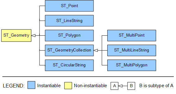
Object-oriented properties of spatial data types:
- A subtype (or derived type) is more specific than its supertype (or base type).
- A subtype inherits all methods from all supertypes. For example,
ST_Polygonvalues can call methods defined for theST_Geometry. - A value of a subtype can be automatically converted to any of its supertypes. For example, an
ST_Pointvalue can be used where anST_Geometryparameter is required. - A column or variable of type
ST_Geometrycan store spatial values of any type.
For the purpose of this tutorial, create a schema TUTORIAL_GEO or use any other schema in your instance, where you have privileges for creating tables.
CREATE SCHEMA "TUTORIAL_GEO";
SET SCHEMA "TUTORIAL_GEO";
Create and load data into the SpatialShapes table. This example is taken from the SAP HANA Spatial Reference. You can run exercises from the official help as well.
CREATE COLUMN TABLE SpatialShapes
(
  ShapeID integer,
  shape ST_GEOMETRY
);
Insert following sample data.
-- a set of points
INSERT INTO SpatialShapes VALUES(1,  NEW ST_POINT('POINT(2.5 3.0)'));
INSERT INTO SpatialShapes VALUES(2,  NEW ST_POINT('POINT(3.0 4.5)'));
INSERT INTO SpatialShapes VALUES(3,  NEW ST_POINT('POINT(3.0 6.0)'));
INSERT INTO SpatialShapes VALUES(4,  NEW ST_POINT('POINT(4.0 6.0)'));
INSERT INTO SpatialShapes VALUES(5,  NEW ST_POINT());

-- a set of linestrings
INSERT INTO SpatialShapes VALUES(6,  NEW ST_LINESTRING('LINESTRING(3.0 3.0, 5.0 4.0, 6.0 3.0)'));
INSERT INTO SpatialShapes VALUES(7,  NEW ST_LINESTRING('LINESTRING(4.0 4.0, 6.0 5.0, 7.0 4.0)'));
INSERT INTO SpatialShapes VALUES(8,  NEW ST_LINESTRING('LINESTRING(7.0 5.0, 9.0 7.0)'));
INSERT INTO SpatialShapes VALUES(9,  NEW ST_LINESTRING('LINESTRING(7.0 3.0, 8.0 5.0)'));
INSERT INTO SpatialShapes VALUES(10,  NEW ST_LINESTRING());

-- a set of polygons
INSERT INTO SpatialShapes VALUES(11, NEW ST_POLYGON('POLYGON((6.0 7.0, 10.0 3.0, 10.0 10.0, 6.0 7.0))'));
INSERT INTO SpatialShapes VALUES(12, NEW ST_POLYGON('POLYGON((4.0 5.0, 5.0 3.0, 6.0 5.0, 4.0 5.0))'));
INSERT INTO SpatialShapes VALUES(13, NEW ST_POLYGON('POLYGON((1.0 1.0, 1.0 6.0, 6.0 6.0, 6.0 1.0, 1.0 1.0))'));
INSERT INTO SpatialShapes VALUES(14, NEW ST_POLYGON('POLYGON((1.0 3.0, 1.0 4.0, 5.0 4.0, 5.0 3.0, 1.0 3.0))'));
INSERT INTO SpatialShapes VALUES(15, NEW ST_POLYGON());
Now, check the shapes you loaded, including types of geometries and which geometry values represent empty sets.
SELECT "SHAPEID", "SHAPE".ST_asWKT(), "SHAPE".ST_GeometryType(), "SHAPE".ST_isEmpty()
FROM "TUTORIAL_GEO"."SPATIALSHAPES";
Consider the following example.
SELECT NEW ST_LINESTRING('LINESTRING(1.0 2.0, 1.0 2.0)').st_IsValid() AS "IS_VALID"
FROM "DUMMY";
The result of the query is 0, meaning the shape is not valid. In this example the beginning and the end points of a single line string cannot are the same.
Now insert this string into the table.
INSERT INTO SpatialShapes
VALUES(100,  NEW ST_LineString('LINESTRING(1.0 2.0, 1.0 2.0)'));
The insert will be successful and the new row with the invalid shape is added to the table. This is because by default there is no additional validation done on spatial columns as can be seen in the view ST_GEOMETRY_COLUMNS.
SELECT "TABLE_NAME", "COLUMN_NAME", "VALIDATION"
FROM "ST_GEOMETRY_COLUMNS"
WHERE "SCHEMA_NAME"='TUTORIAL_GEO' AND "TABLE_NAME"='SPATIALSHAPES';
Alter the definition of the table’s column to do validation checks now. Check how values are changes in the view ST_GEOMETRY_COLUMNS.
ALTER TABLE "TUTORIAL_GEO"."SPATIALSHAPES" ALTER ("SHAPE" ST_GEOMETRY(0) VALIDATION FULL);Try to insert invalid shape into the column once again.
INSERT INTO SpatialShapes VALUES(101, NEW ST_LINESTRING('LINESTRING(1.0 2.0, 1.0 2.0)'));This time you should receive an error message, like following: spatial error: The geometry is considered invalid by function ST_IsValid, but only valid geometries are allowed for column...
Altering column to turn validations on does not do revalidation of already inserted data and applies only to new and modified data.
Remove these test records from the table as they won’t be needed in further exercises.
DELETE FROM "TUTORIAL_GEO"."SPATIALSHAPES" WHERE "SHAPEID" > 15;When you need to combine multiple shapes into one you can use different set operations and aggregation methods.
Aggregation methods are executed on spatial columns of tables in SAP HANA.
ST_UnionAggr() returns the spatial union of all of the geometries in a column.
SELECT ST_UnionAggr(SHAPE).ST_asWKT() as "UnionAggr"
FROM "TUTORIAL_GEO"."SPATIALSHAPES"
WHERE "SHAPE".ST_isEmpty()=0 and "SHAPE".ST_GeometryType() = 'ST_LineString';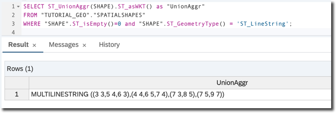
Presented graphically, it looks like the diagram below:

Also note that spatial predicates were used in the query above to select only geometries of type LineString type and only those that are not empty.
Check-your-knowledge exercises
- Query the union aggregation of polygons from the table.
- Query the union aggregation of boundaries of polygons from the table.
Two other important aggregate methods are:
ST_EnvelopeAggr()which returns the bounding rectangle for all of the geometries in a group,ST_ConvexHullAggr()which returns the convex hull for all of the geometries in a group, known as “rubber band” method.
Execute this query to best illustrate both types of aggregations. It uses the set operation method ST_Union() to return the geometry value that represents the point set union of two geometries.
SELECT
ST_ConvexHullAggr("SHAPE").ST_Boundary().ST_Union(ST_UnionAggr("SHAPE")).ST_asWKT() AS "ConvexHullAggr",
ST_EnvelopeAggr("SHAPE").ST_Boundary().ST_Union(ST_UnionAggr("SHAPE")).ST_asWKT() AS "EnvelopeAggr"
FROM "TUTORIAL_GEO"."SPATIALSHAPES"
WHERE "SHAPE".ST_isEmpty()=0 and "SHAPE".ST_GeometryType() = 'ST_LineString';
Please note the use of the ST_Boundary() method to convert a polygon (which is a result of the aggregation) into just a curve surrounding the shape, so that the combined geometries are all visible.

Seeing is believing, so here are the graphical outputs (with slightly modified SVG to draw the shapes of the aggregates in red)
The result of ST_ConvexHullAggr():

And the result of ST_EnvelopeAggr():

- Example: Calculating number π by throwing darts
- Check the SAP HANA Spatial Reference
Resources
Discussion
Share feedback on this tutorial or join the conversation in SAP Community.