
Use a Cost Function to Calculate Shortest Path
Learn how to use a more complex cost function to calculate shortest paths and how to wrap this procedure into a table function to compare different paths.
Overview
You will learn
- How to calculate shortest path based on a cost function
- How to use insert a condition in the cost function
- How to wrap a GRAPH procedure in a table function


Prerequisites
Prerequisites
- You have already created a Graph Workspace using the tutorial First steps with the SAP HANA Graph Engine.
- You have access to the sample graph data used in this tutorial group.
- Make sure your database instance is running before you start.
Steps
Intro
In the previous tutorial, you used hop distance to calculate a shortest path. Now you will use a more meaningful cost function: you derive the time it takes to traverse a street segment.
The EDGES table contains a length and maxspeed column. maxspeed is a string column with values like ‘30 mph’. For this tutorial you first need to create a new numeric column SPEED_MPH and extract the number part of maxspeed into this column. Your next step will be to re-write the procedure to take the expression “length/SPEED_MPH” as cost function.
This tutorial consists of four steps:
- Generate a numeric column that contains the maximum speed allowed information
- Calculate the shortest path to minimize the time spent
- Find Pubs and Bike lanes
- Wrap a GRAPH procedure in a Table Function
First, you need to add an integer column to the LONDON_BIKE_EDGES table. Extract the number part of maxspeed by executing this statement:
ALTER TABLE "LONDON_EDGES" ADD("SPEED_MPH" INT);
UPDATE "LONDON_EDGES"
	SET "SPEED_MPH" = TO_INT(REPLACE("maxspeed", ' mph', ''))
	WHERE REPLACE("maxspeed", ' mph', '') <> "maxspeed" ;
SELECT "SPEED_MPH", COUNT(*) AS C FROM "LONDON_EDGES" GROUP BY "SPEED_MPH" ORDER BY C DESC;
-- let's add a default value on the segments that do not have a speed information
UPDATE "LONDON_EDGES" SET "SPEED_MPH" = 30 WHERE "SPEED_MPH" IS NULL;
In the Result panel you can see the distribution of the SPEED_MPH column after updating with default values.

Just like in the previous tutorial, you need to define a table type and a procedure. This time, use “length/SPEED_MPH” as cost function. Syntactically, the cost function is a lambda function like this:
(Edge e) => DOUBLE{ return :e."length"/DOUBLE(:e."SPEED_MPH"); }Copy and paste this statement to your SQL console and execute it to create the procedure:
CREATE TYPE "TT_SPOO_WEIGHTED_EDGES" AS TABLE (
    "ID" NVARCHAR(5000), "SOURCE" BIGINT, "TARGET" BIGINT, "EDGE_ORDER" BIGINT, "length" DOUBLE, "SPEED_MPH" INT
);


CREATE OR REPLACE PROCEDURE "GS_SPOO_WEIGHTED"(
	IN i_startVertex BIGINT, 		-- INPUT: the ID of the start vertex
	IN i_endVertex BIGINT, 			-- INPUT: the ID of the end vertex
	IN i_direction VARCHAR(10), 	-- INPUT: the direction of the edge traversal: OUTGOING (default), INCOMING, ANY
	OUT o_path_length BIGINT,		-- OUTPUT: the hop distance between start and end
	OUT o_path_weight DOUBLE,		-- OUTPUT: the path weight/cost
	OUT o_edges "TT_SPOO_WEIGHTED_EDGES"  -- OUTPUT: the edges that make up the path
	)
LANGUAGE GRAPH READS SQL DATA AS BEGIN
	-- Create an instance of the graph, referring to the graph workspace object
	GRAPH g = Graph("DAT260", "LONDON_GRAPH");
	-- Create an instance of the start/end vertex
	VERTEX v_start = Vertex(:g, :i_startVertex);
	VERTEX v_end = Vertex(:g, :i_endVertex);
	--WeightedPath<DOUBLE> p = Shortest_Path(:g, :v_start, :v_end, (Edge e) => DOUBLE{ return :e."length"; }, :i_direction);
	WeightedPath<DOUBLE> p = Shortest_Path(:g, :v_start, :v_end,
		(Edge e) => DOUBLE{
			return :e."length"/DOUBLE(:e."SPEED_MPH");
		}, :i_direction);
	o_path_length = LENGTH(:p);
	o_path_weight = WEIGHT(:p);
	o_edges = SELECT :e."ID", :e."SOURCE", :e."TARGET", :EDGE_ORDER, :e."length", :e."SPEED_MPH" FOREACH e IN Edges(:p) WITH ORDINALITY AS EDGE_ORDER;
END;Next, call the procedure by executing this statement:
CALL "GS_SPOO_WEIGHTED"(1433737988, 1794145673, 'ANY', ?, ?, ?);
If you visualize the procedure on a map, it should look like this:
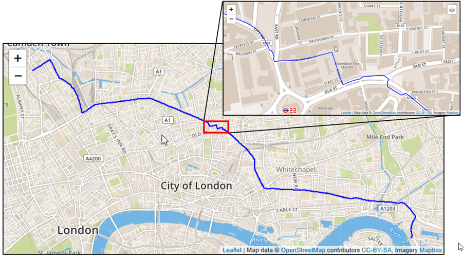
Finding the fastest route is easy. Let’s find two more interesting paths. First, you need to find paths suitable for bikes. You can do so by boosting street segments which are “cycleways”.
Note that in most cases you cannot take cycleways only. The path algorithm will choose cycleways unless they are 10x longer than a normal road.
For this logic you will use an IF statement within the cost function.
Second, you would like to find “attractive” paths. You will calculate a new measure for the edges - “PUBINESS” - which is derived from the number of pubs nearby.
First, let’s calculate
PUBINESSby counting pubs within 100m distance and add this to ourLONDON_EDGEStable. You are using the spatialST_WithinDistancepredicate as join condition:SQL
ON pubs.“SHAPE”.ST_WithinDistance(e.“EDGESHAPE”, 100) = 1
2. This is the complete statement to alter the table and adding our **`PUBINESS`** measure. Paste and execute it:

    ```SQL
ALTER TABLE "LONDON_EDGES" ADD ("PUBINESS" DOUBLE DEFAULT 0);
MERGE INTO "LONDON_EDGES"
USING (
		SELECT e."ID", COUNT(*) AS "PUBINESS" FROM
			(SELECT * FROM "LONDON_POI" WHERE "amenity" ='pub') AS pubs
			LEFT JOIN
			(SELECT "ID", "SHAPE" AS "EDGESHAPE" FROM "LONDON_EDGES") AS e
			ON pubs."SHAPE".ST_WithinDistance(e."EDGESHAPE", 100) = 1
			GROUP BY e."ID" ORDER BY "PUBINESS" DESC)	AS U
	ON "LONDON_EDGES"."ID" = U."ID"
WHEN MATCHED THEN UPDATE SET "LONDON_EDGES"."PUBINESS" = U."PUBINESS";
Using this statement, you can check the distribution of this new
PUBINESSproperty.SQL
SELECT “PUBINESS”, COUNT(*) AS C FROM “LONDON_EDGES” GROUP BY “PUBINESS” ORDER BY “PUBINESS” ASC;
4. This is what the results should look like:
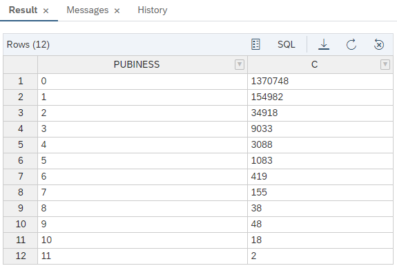
Now, you can use the new measure as part of the cost function for path finding with mode "**pub**".
```
Shortest_Path(:g, :v_start, :v_end, (Edge e) => DOUBLE {
RETURN :e."length"/(5.0*:e."PUBINESS"+1.0);
}, :i_direction);For finding the path with mode "**bike**", you can use a conditional cost function. Street segments which are of type "**cycleway**" are boosted by dividing the length by 10.
```SQL
Shortest_Path(:g, :v_start, :v_end, (EDGE e)=> DOUBLE { IF(:e.“highway” == ‘cycleway’) { RETURN :e.“length”/10.0; } ELSE { RETURN :e.“length”; } }, :i_direction);Shortest_Path(:g, :v_start, :v_end, (EDGE e)=> DOUBLE { IF(:e.“highway” == ‘cycleway’) { RETURN :e.“length”/10.0; } ELSE { RETURN :e.“length”; } }, :i_direction);
5. Create a **TABLE TYPE** first with the following statement.

    ```SQL
CREATE TYPE "TT_SPOO_MULTI_MODE" AS TABLE (
		"ID" NVARCHAR(5000), "SOURCE" BIGINT, "TARGET" BIGINT, "EDGE_ORDER" BIGINT, "length" DOUBLE, "SPEED_MPH" INT, "highway" NVARCHAR(5000)
);
Then create the procedure with this statement.
SQL
CREATE OR REPLACE PROCEDURE “GS_SPOO_MULTI_MODE”(
IN i_startVertex BIGINT, – the ID of the start vertex
IN i_endVertex BIGINT, – the ID of the end vertex
IN i_direction VARCHAR(10), – the the direction of the edge traversal: OUTGOING (default), INCOMING, ANY
IN i_mode VARCHAR(10), – hop, time, bike
OUT o_path_length BIGINT, – the hop distance between start and end
OUT o_path_weight DOUBLE, – the path weight/cost based on the WEIGHT attribute
OUT o_edges “TT_SPOO_MULTI_MODE”
)
LANGUAGE GRAPH READS SQL DATA AS BEGIN
GRAPH g = Graph(“DAT260”, “LONDON_GRAPH”);
VERTEX v_start = Vertex(:g, :i_startVertex);
VERTEX v_end = Vertex(:g, :i_endVertex);
– mode=bike means cycleway preferred
IF (:i_mode == ‘bike’) {
WeightedPath
7. To see the results, you can again use a **CALL** statement:

    ```SQL
CALL "GS_SPOO_MULTI_MODE"(1433737988, 1794145673, 'ANY', 'pub', ?, ?, ?);
CALL "GS_SPOO_MULTI_MODE"(1433737988, 1794145673, 'ANY', 'bike', ?, ?, ?);The procedure above returns more than one output - the path’s length, weight, and a table with the edges. Sometimes it is convenient to wrap a GRAPH procedure in a table function, returning only the tabular output. Table functions are called via SELECT and are a convenient way to post-process graph results - you can use the full power of SQL on your graph results. This is how you do it:
First, as in the previous examples, create the TABLE TYPE:
SQL
CREATE TYPE “TT_EDGES_SPOO_F” AS TABLE ( “ID” NVARCHAR(5000), “SOURCE” BIGINT, “TARGET” BIGINT, “EDGE_ORDER” BIGINT, “length” DOUBLE, “SHAPE” ST_GEOMETRY(32630) ); ```
Then create the function:
SQL
CREATE OR REPLACE FUNCTION “F_SPOO_EDGES”( IN i_startVertex BIGINT, IN i_endVertex BIGINT, IN i_direction VARCHAR(10), IN i_mode VARCHAR(10) ) RETURNS “LONDON_EDGES” LANGUAGE SQLSCRIPT READS SQL DATA AS BEGIN DECLARE o_path_length DOUBLE; DECLARE o_path_weight DOUBLE; CALL “GS_SPOO_MULTI_MODE”(:i_startVertex, :i_endVertex, :i_direction, :i_mode, o_path_length, o_path_weight, o_edges); RETURN SELECT lbe.* FROM :o_edges AS P LEFT JOIN “LONDON_EDGES” lbe ON P.“ID” = lbe.“ID”; END; ```
Now you can simply calculate the average
PUBINESSof a path, or UNION two paths to compare. To calculate the average value of one path, use this statement:SQL
SELECT AVG(“PUBINESS”) FROM “F_SPOO_EDGES”(1433737988, 1794145673, ‘ANY’, ‘pub’); ```
To compare two paths, you can use this statement:
SQL
SELECT “ID”, “SHAPE” FROM “F_SPOO_EDGES”(1433737988, 1794145673, ‘ANY’, ‘pub’) UNION SELECT “ID”, “SHAPE” FROM “F_SPOO_EDGES”(1433737988, 1794145673, ‘ANY’, ‘bike’); ```
Visualizing this comparison should look like this:

TWO PATHS
You now have used two more cost functions for path finding. You have wrapped the GRAPH procedure into a table function which can be called in a SQL SELECT statement. This is a nice way of mixing graph and relational processing.
In the next tutorial, learn how to calculate
isochronesand closeness centrality.
Resources
Discussion
Share feedback on this tutorial or join the conversation in SAP Community.